Mapping the Scottish Colony 'New Caledonia'
Scottish independence has been in the news for a while, especially given the escalating conflict and tension between Holyrood and Westminster Parliaments. Several writers, pundits, and politicians have written hundreds of articles for-and-against independence, and it’ll probably stay that way for years to come.
Every[1] now[2] and[3] then,[4] some writer will bring up the old tale called The Darien Scheme. It’s commonly known as Scotland’s catastrophic failure to create a colony called ‘New Caledonia’ during the late 1690s in Darien, Panama. Typically the writer uses it as a narrative-device to imply that the Scottish independence movement would repeat history and result in a similar economic and national disaster. That rhetoric may convince some people, however the same writers are typically supporters of political parties that support Brexit, so make of that what you will…
But every time the story of the Darien Scheme came up, I kept wondering about the details of the venture. Where in Panama was it? How big was the settlement? What was the landscape like?
Several articles I read on the topic weren’t that insightful. While they had some neat photos that described the climate and vegetation, I wanted details about the settlement itself!
To remedy this gap in knowledge, this post will:
- explore the geo-political landscape of the late 1690s,
- share some historical maps of ‘New Caledonia’, and
- provide context of what it looks like today.
The Darien Scheme?
A quick-ish recap, for those unfamiliar…
It was the 1690s and Scotland was in trouble. A prolonged famine, war, and economic pressure from England, meant Scotland had to grow to survive.
One of several solutions proposed was colonialism. 200 years after Columbus’s discovery of America, colonial powers including Spain, Portugal, France, and England had a strong foothold in America. While Scotland had already tried creating North American settlements in Nova Scotia, New Jersey, and Carolina, these were largely unsuccessful due to indigenous, Spanish, English, and even Royal opposition. A different strategy was needed…

By the end of the 1600s, Spain, Portugal, France, and England already had a major presence spanning both hemispheres of America.[5] In desperation, Scotland sailed to the isthmus of Panama hoping for a breakthrough.
The new strategy was bold and ambitious – Setup a colony on the narrow isthmus of Panama which can then be used to connect the Atlantic and Pacific for trade. Today the country of Panama is well known for its canal and its major role in global trade, so the general idea was not that bad. But it was definitely ambitious, especially for Scotland.
But alas, it was a disaster.
The first expedition with 1,200 settlers made landfall in November 1698. Eight months later the settlement was abandoned due to illness, famine, and trade embargoes from the English (encouraged by King William Ⅱ/Ⅲ). Before news had reached Scotland, a second expedition with another 1,300 settlers arrived in November 1699. Four months later, the colony suffered a similar fate, but its collapse was hastened by the Spanish sieging the settlement.
Thousands of people died, Scotland lost a fifth of its wealth,[6] and the nation was demoralized.
Some historians say the Darien Scheme lead directly to the 1707 Act of Union, which united England and Scotland into the Kingdom of Great Britain (But others might down-play its role, and instead say it was the 1705 Alien Act that finally triggered it.)
This BBC History archive provides some more detail on the scheme. For further reading I’d also recommend The Darien Disaster by John Prebble.
But where in Panama was this settlement?
New Caledonia Bay
The location the settlement was not chosen on a whim.
Very precise instructions were given to the ship navigators, however they were kept secret to avoid interception by the English and Spanish. Only after reaching Madeira, a stopover island near Africa, were the ship navigators given permission to open instructions.
The instructions read:
You are hereby ordered in pursuance of your voyage to make the Crab Island, and if you find it free to take possession thereof in name of the Company; and from thence you are to proceed to the Bay of Darien, and make the Isle called the Golden Island, in and about eight degrees of north latitude; and there make a settlement on the mainland as well as the said island, if proper (as we believe) and unpossessed by an European nation or state in amity with his Majesty.[7]
But this part of the world was hardly “unpossessed” by European nations…

New Caledonia was established in an area well settled by the Spanish Empire. For example, Nombre de Dios was 230km away from it, which at 5 knots is only a day away.
Panama already had quite a few Spanish settlements; The Scottish knew this, and took a gamble anyway.
So why did they pick this spot exactly?
I couldn’t find any specific quotes, but looking at it practically, there are three perks: It’s fairly distant from Spain’s biggest settlement ‘Portobelo’, it’s a short travel-distance across the isthmus, and finally, the alluring name ‘Golden Island’ was perhaps a selling point.
What the Scots were not prepared for was the climate, the terrain, and the vegetation. It’s constantly raining, the hills hard to traverse, and the area is covered in rainforest. Traversing ~65 kilometers through what is known today as the ‘Darien Gap’ would be painful. The Scottish Company planning the scheme were warned by the experienced explorer Lionel Wafer, but those warnings were completely ignored. In fact, they regarded not settling a colony at Darien as a “stupid oversight” by the Spanish.[8]
By the time the first ships arrived at Golden Island in November 1698, hundreds of passengers will have died to illness. To make their journey worthwhile, they next had to create a settlement.

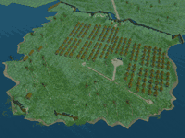
Map of the Bay of Caledonia and it's surroundings. To the north-west are the Sambalas Isles, a collection of small islands.
After looking around the coastline for a few days, they settled in a nearby bay with good shelter and defense and called their new home ‘New Caledonia’. Several months later they would have dozens of huts built and setup the palisade walls for ‘Fort St. Andrew’.
All of it would be in ruins in less than a year.

My artistic rendering of Fort St. Andrew. The fort housed dozens of huts. A wall and moat were constructed to protect against land invasion.
Historical Maps
During my research I managed to find several maps of the colony, but I’ve selected a few that each have a unique perspective.
We’ll start off with the map that seems to be published the most in books and news articles.
An Optimistic Report from the First Expedition
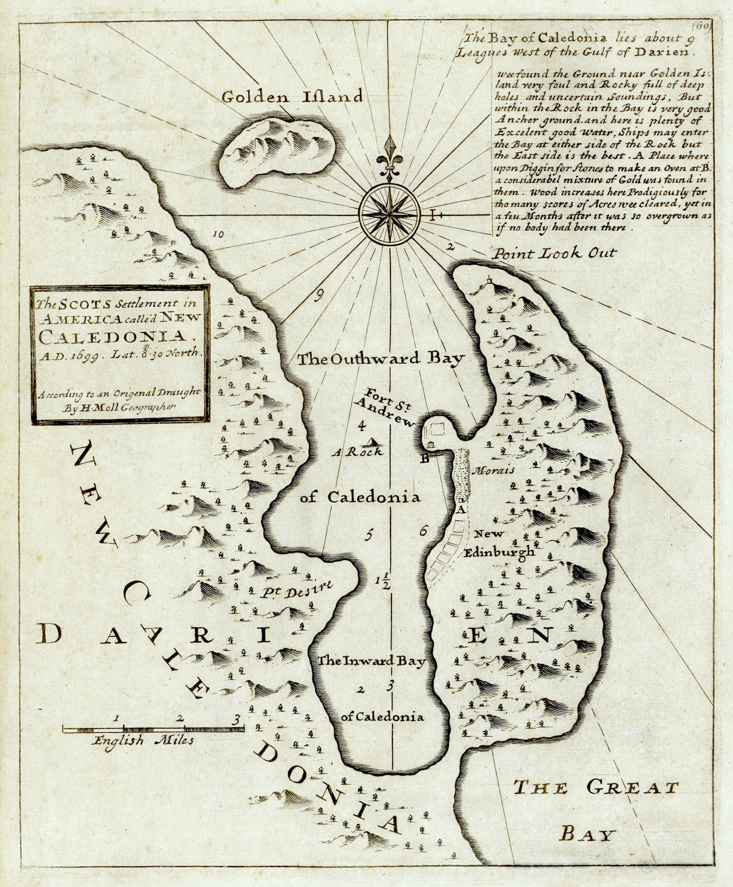
Map of New Caledonia by Herman Moll, drafted in 1699, published in the 1720s.
Full resolution available at the Nationaal Archief. Licensed under CC0.
The first map is a surprisingly accurate map of the bay, and appears to be based on reports from the first expedition that arrived in Panama. While we know that Herman Moll made the map, I couldn’t find any information about who originally drafted the map. It could not have been Moll himself because he was not part of the expedition.
Whoever the original author was, it’s still interesting to highlight the paragraph in the top-right of the map.
We found the ground near Golden Island very foul and rocky, full of deep holes and uncertain soundings. But within the rock in the bay is very good anchor ground, and here is plenty of excellent good water. Ships may enter the bay at either side of the rock but the East side is the best. 𝐀. Place where upon digging for stones to make an oven at 𝐁., a considerable mixture of gold was found in them. Wood increases here prodigiously for tho many scores of acres we cleared, yet in a few months after it was so overgrown as if no body had been there.
Doesn’t sound too bad right? Safe harbour, gold, and fertile land!
Firstly, the rocks in the harbour did make maneuvering ships inconvenient and a constant hazard.[9] Secondly, the discovery of gold was an exaggeration.[10] And finally, while there was plenty of vegetation and wood, the colonists spent months clearing room for the fort. They never even managed to setup a plantation.[11]
The fort’s ground surface was also questionable. Taking a closer look at the map, the area beneath Fort St. Andrew is labelled ‘Morais’, which is probably the old english spelling for ‘morass’ – a marsh or swamp. In reality, the whole region consisted of unstable ground and the constant rains turned all the paths into “runnels of mud”.[12]
To the south of the fort is a plot of land labelled ‘New Edinburgh’. I could not find any references explaining what the plot of land was used for, but it’s either a planned site for buildings, or it was the initial location where camps were setup when the first expedition arrived.[13] No other maps I could find describe any settlements along the coastline. Keep in mind that this is a kilometer or more away from the fort, so it probably would not be convenient to build infrastructure so far away.
There are several other details that may be misleading to someone not familiar with antique maps, such as the hill and tree illustrations. While it looks like a meadow populated with sparse trees, it’s actually a dense rainforest. The peninsula also isn’t a collection of hills, it’s one massive hill reaching 180 meters. This isn’t the fault of the map-maker, this is just how maps were stylised at the time.
I’ve found that this map is probably referenced the most in online articles and YouTube documentaries, mainly because it’s pretty nice looking.
But there are other maps, albeit less appealing, such as this next map by a missioner…
A Missioners Account of the Second Expedition
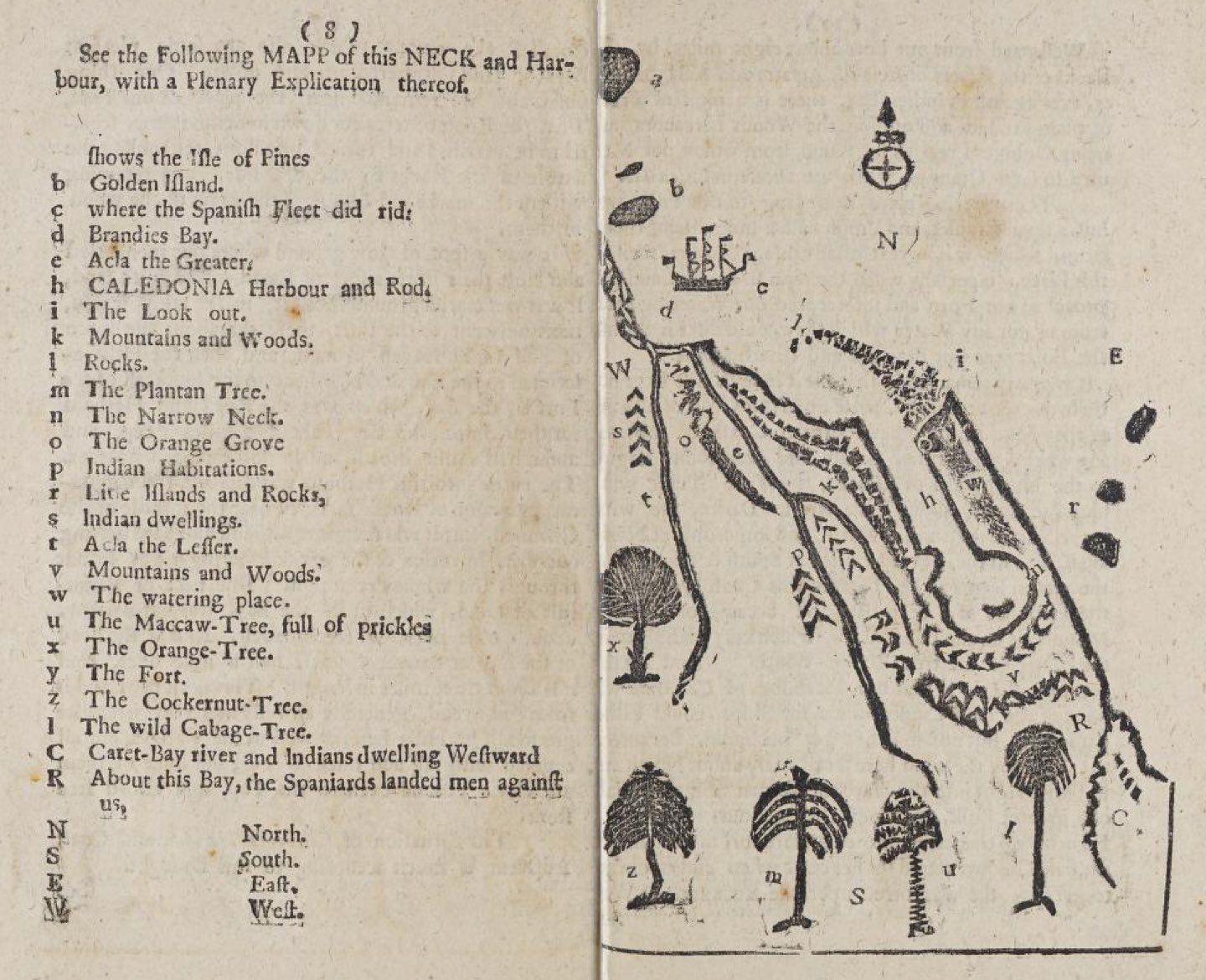
Map by Francis Borland, published in Memoirs of Darien, 1715.
Full resolution available at the Archive.org.
This second map is by Francis Borland, a Scottish Presbyterian missioner for the Church of Scotland. He was on the second expedition to Panama, and arrived upon the shores of New Caledonia expecting to find the bustling town of New Edinburgh. The stark reality shocked the new settlers as they discovered burnt down structures and an overgrown fort.[14] The news of the first colony’s collapse hadn’t reached them when they set sail. Amazingly, and perhaps foolishly, they had the courage to rebuild.
While the map is a crude illustration, it makes up for it with detail.
I like the map because it shows details like rivers (‘Acla the greater’, and ‘Acla the lesser’), the nearby villages of indigenous people, and even the different types of vegetation. The rivers and villages were only about 5 kilometers away from the fort, but navigating through the trees, streams, and steep hills was exhausting and took a whole day to reach.[15]
Unfortunately, the map does not show any details about the colony itself, but it does show the ‘watering place’, labelled w, located just outside the fort. Its location will play an important role later when the Spanish arrive.
Considering this was sketched out by a minister I would say it’s a fairly decent map that gets the details right. At least, compared to other maps I’ve seen.
The map does hint of our story’s conclusion – Labelled R, “About this Bay, the Spaniards landed men against us”…
The Spanish Empire Strikes Back
Four months after the new colony was setup, the Spanish had enough of the Scots encroaching on their territory; especially after a recent skirmish by the Scots at a nearby Spanish outpost called Tubacanti.[16]
The next two maps were made by Royal Engineer Don Juan de Herrera y Sotomayor, which document how the Spanish sieged New Caledonia. Of all the maps that I found, these were the highest quality, and it demonstrates the surveying and intelligence capabilities of the Spanish Army. The Spanish understood that the Scots were wind-locked in the bay and any escape would be very difficult.[17] The bay was surrounded by Spanish sea forces, people were still dying from sickness, and supplies were limited. It was only a matter of time before the Scots would capitulate.[18]
This first map tells the story of how the Spanish approached the fort over a period of over 3 weeks. The map is a little simplistic with the timeline, as there were several skirmishes between the Scots and the Spanish throughout the siege. The Spanish first landed on Caret Bay on March the 10th, several kilometers away from Caledonia Bay. On March the 28th, the Spanish reached the woods outside of the fort. Two days later the Spanish even managed to land an artillery battery pointed straight at the fort only 250 meters away. Finally, on March the 31st, the Scots capitulated.[19]
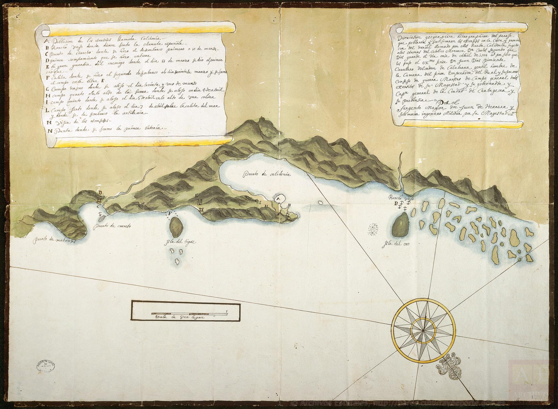
Map showing the bay and the fort, made by Herrera in 1700. Spanish camps and a trail were established along the coast, eventually reaching the Scottish Fort.
Full version available at the Spanish Archives.
- The Scottish settlement called Caledonia
- Rancho Viejo where the Spanish Armada anchored
- Caret Bay where the first landing was made on March 10th
- First shelter made on land
- Here we first clashed with enemy guards on March 11th
- Bay where the second landing was made on March 30th and the camp in the letter E. was ambushed
- Third camp where we stayed on March 31st
- Fourth camp where we stayed on April 4th
- Fifth camp where we stayed on April 6th at the top of the hill
- Sixth camp where we stayed on April 7th and where the artillery was landed
- Scottish Watchtower
- Point where the first batteries were deployed
It’s interesting to see that the Scots had lookouts in two places, E and M. One at the tip and one at the neck of the peninsula.
The next map shows a close up view of the Spanish army’s siege at Fort St. Andrew.
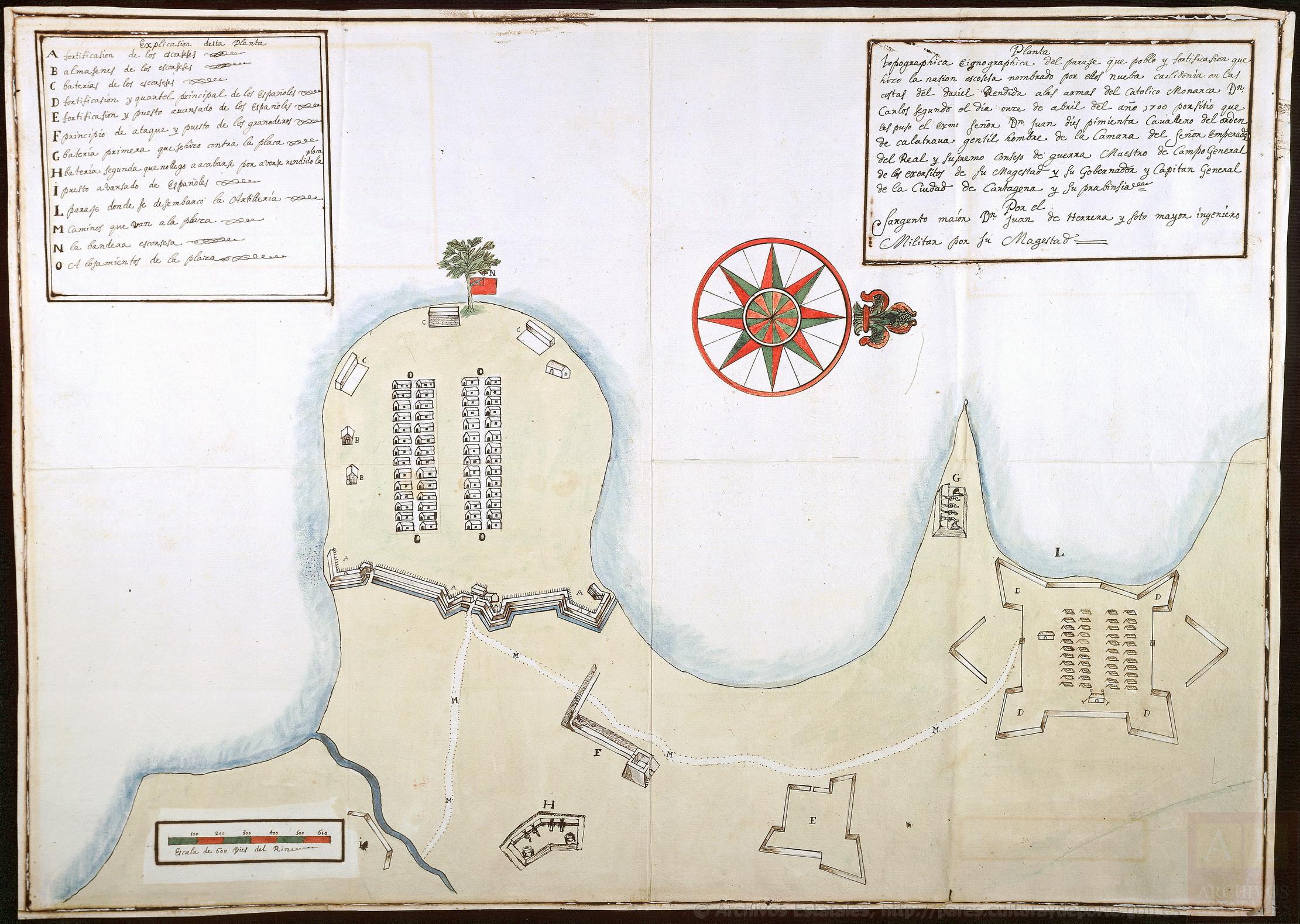
Map of the fortifications in and around Fort St. Andrew, made by Herrera in 1700.
Full resolution available at the Spanish Archives.
- Scottish fortifications
- Scottish warehouses
- Scottish batteries
- Spanish fortifications for the primary quarters
- Spanish fortifications for an outpost
- Spanish outpost for grenadiers for the main attack
- First batteries that were used against the settlement
- Second batteries that were not finished because they surrendered
- Spanish Outpost
- Where the artillery was landed
- Paths to the settlement
- The Scottish Flag
- Accommodations
The map shows the position of the Spanish army camps half a kilometer away. Based on the dates of the previous map, it seems like this camp was setup after the Scots capitulated, but the artillery at G was definitely setup before then.
The map also shows the general layout of the fort, which no other map of New Caledonia I’ve come across includes. In the center were all the huts used as accommodations, and on the edges of the fort were warehouses and artillery. At the top edge is a nice illustration of a tree flying the Scottish Red Ensign Flag.
On the top-right edge of the fort is a large building which was probably the warehouse that had been converted later by the Spanish commander Don Juan Pimienta as the “first temple, where the first mass was said, consecrating the place to Saint Charles”.[20]
Of particular note is the water stream in the lower-left. This stream was used by the Scots as their fresh-water supply. But because it was located half a mile away from the fort, and was completely surrounded by the Spanish at the final stages of the siege, the distressed Scots had to drink “brackish, puddle-unwholesome water” from within the palisade walls.[21]
It’s likely that several aspects of the map shouldn’t be interpreted literally. For example, while the walls of the fort appear to look like stone on the map, in reality the fortifications were palisade walls mostly made up of wood.
After conquering the settlement, the Spanish tried to keep a foothold with 200 men in New Caledonia for almost a year. But in a report written in April 1701, a Spanish admiral claims that the majority of men had either deserted, died from illness, or were attacked by pirates. The settlement, renamed “Plaza Caledonia”, was abandoned later that year.[22]
Modern Maps
300 years later, what’s left of the settlement?
Satellite imagery is very hard to come by in this region of the world as clouds are constantly obstructing the view. Google Maps has very low resolution imagery, making it useless. Bing Maps is a bit cloudy, but it’s possible to see individual trees. But looking from above that’s all one can see – just trees. 🌴
Thankfully several archeological expeditions have been made to investigate the site more closely.
According to a BBC article, the only thing left is the trench that the settlers dug for the fort. The article has some pictures.
One expedition in 1979, named “Operation Drake”, surveyed the site and collected various artifacts. Christopher Sainsbury has published photos of this expedition on Flickr.
Another expedition in the early 2000s discovered some structures including what appears to be an oven. From this expedition a BBC documentary titled “Darien - A Disaster in Paradise” was created. The full documentary no longer appears to be publicly available, but one of the archaeologists has shared a clip online.
Another BBC article from 2005 shows a computer-generated image of the settlement from an exhibition held in Panama or possibly for the aforementioned BBC documentary. Their recreation shows 190 huts, a few warehouses on the coast, and an outline of the fortifications. This roughly matches the layout shown in Herrera’s maps.

A digital recreation of the settlement showing Fort St. Andrew, produced by the University of Bristol.
Sourced from BBC and UoB.
Conclusion
So it turns out we actually know a fair amount about New Caledonia! More than I had originally anticipated anyway. While we don’t have a full map of every building of the settlement, we do have a rough idea of how the colony was organized, partially in thanks to the maps by Spanish Engineer Herrera y Sotomayor. There’s also several written accounts of the colony, which without would not have made it possible to corroborate the information shown on the maps.
This post focused mainly on historical maps, but during my research I discovered there’s some recent map news relevant to New Caledonia!
Until fairly recently, the bay was called ‘Puerto Escocés’, Spanish for Scottish Port. In 2011 the Panama’s National Assembly renamed it ‘Sukunya Inabaginya’.[23] The new name honours General Inabaginya, who, unlike the Scots, succeeded in making the area habitable in 1914 and was a huge support for the local community.[24] So now, by law, maps should no longer display the name Puerto Escocés.
I thought this might be the “final death” of the Scot’s legacy in Panama as their presence is erased from the map. But it turns out the locals in a nearby village have continued to pay tribute to the Scottish people by naming their island Caledonia. So, for now at least, the Darien scheme’s legacy will continue to live on the maps of Panama.
Appendix
During my research I discovered several historical maps of the colony, which I’ve listed in the table below. The first four in the list are maps discussed above. The rest are maps that I felt didn’t really add more detail to the story, as some maps appear to be derivatives of other maps.
 |
The Scots Settlement in America, called New-Caledonia, A.D. 1699 Nationaal Archief |
 |
Memoirs of Darien Archive.org |
 |
Descricsion geográphica hidrográphica del parage que poblaron y fortificaron los escorseses en la costa y prouincia del dariel llamado por ellos nueba Calidonia Spanish Archives |
 |
Planta Topográphica é ignográphica del parage que pobló y fortificasión que hizo la nasión escorsesa nombrado por ellos nueba calidonia en las costas del darien Spanish Archives |
 |
Plano Del Puerto dela Calidonia Virtual Defense Library |
 |
Map promoting Scotland’s “Darien Scheme” in Panama Boston Rare Maps |
 |
Rade du Darien et les isles voisines David Rumsey Map Collection |
 |
A New Map of the Isthmus of Darian in America & Bay of Panama The Gulph of St. Michal with Its Islands, & Countries Adjacent JCB Map Collection |
 |
Carte Particuliere de Isthmus ou Darien qui Comprend le Golfe de Panama &c. Cartagena, et les Isles aux Environs RareMaps.com |
 |
An exact draught of the gulf of Darien & the coast to Porto Bello with Panama in the south sea & the Scotch settlement in Calledonia Norman B. Leventhal Map & Education center |
 |
A contemporary manuscript map of Darien Daniel Crouch Rare Books |
The maps in the beginning section were created by me and are based on OpenStreetMap data and SRTM elevation data. The source code for the first three maps can be found on Codeberg at new-caledonia-maps. The birds-eye view illustration is a composition of 3D terrain software and vector illustration.
I’d also like to give credit to Julie M. Orr for including the Spanish maps by Herrera y Sotomayor. I only discovered the maps through their thesis, and haven’t seen anyone else reference the maps in any other publicly available works. The maps were really helpful for providing a second perspective in the story.
Citations
- ^ Chalmers, “… From Darien to Faslane”
- ^ Ho, “… another Darien Disaster”
- ^ Hogg, “… new Darien scheme”
- ^ Dickie, “… economic plan 'another Darien' …”
- ^ The coloured borders used in the illustration of the globe should be taken with a pinch of salt. They represent areas where the empires had a presence and influence but not necessarily full authority. The borders were derived from this Wikipedia map of the world in 1700.
- ^ Carroll, “The sorry story …”
- ^ Prebble, The Darien Disaster, p. 141
- ^ Prebble, The Darien Disaster, p. 85
- ^ Prebble, The Darien Disaster, p. 154
- ^ Prebble, The Darien Disaster, p. 187
- ^ Prebble, The Darien Disaster, p. 201
- ^ Prebble, The Darien Disaster, p. 213
- ^ Prebble, The Darien Disaster, p. 157
- ^ Prebble, The Darien Disaster, p. 257
- ^ Prebble, The Darien Disaster, p. 267
- ^ Prebble, The Darien Disaster, p. 184, 281. Also spelled Toubacanti. I was unable to find the exact location of Tubacanti, but it was somewhere in the hills between Rio Sabanas on the pacific coast and New Caledonia on the Atlantic coast.
- ^ Orr, New Caledonia's Wake, p. 224
- ^ Orr, New Caledonia's Wake, p. 226
- ^ Prebble, The Darien Disaster, p. 310-319
- ^ Orr, New Caledonia's Wake, p. 233
- ^ Prebble, The Darien Disaster, p. 316-317
- ^ Orr, New Caledonia's Wake, p. 235
- ^ García, “Two laws …”
- ^ Panama National Assembly, Law 145, 2010
References
- Scottish independence: ‘From Darien to Faslane’ – Malcolm Chalmers, published by The Scotsman, 2012
- COMMENT: Scottish independence risks another Darien Disaster – Geoff Ho, published by Express, 2014
- Readers’ Letters: Independence could be new Darien scheme – Ian Hogg, published by The Scotsman, 2021
- Nicola Sturgeon’s economic plan ‘another Darien’ that would ruin country says former government adviser – Douglas Dickie, published by Scottish Daily Express, 2022
- The sorry story of how Scotland lost its 17th century empire – Rory Carroll, published by The Guardian, 2007 (Archive.org)
- The Darien Disaster – John Prebble, published by Penguin Books, 1970 (OpenLibrary.org)
- New Caledonia’s Wake: Expanding the Story of Company of Scotland Expeditions to Darien, 1698-1700 - Orr, J. M., published by University of Dundee, 2014 (University of Dundee)
- Two laws that enshrine the name of Inabaginya – Simón Herrera García, published by Panamá América, 2021 (Archive.org)
- Law 145, 30th of March 2010 – Panama’s National Assembly, published 2010 (Yumpu.com)
- Law 64, 9th of August 2011 – Panama’s National Assembly, published 2011 (GacetaOficial.gob.pa)
Transcripts
For discoverability, below are text transcripts for some of the maps and documents referenced in this post.
Herman Moll's Map
The SCOTS Settlement in AMERICA called NEW CALEDONIA. A.D. 1699. Lat. 8D.-30 North. According to an Origenal Draught By H. Moll Geographer
The Bay of Caledonia lies about 9 Leagues West of the Gulf of Darien.
wee found the Ground near Golden Island very foul and Rocky full of deep holes and uncertain Soundings, But within the Rock in the Bay is very good Anchor ground, and here is plenty of Excelent good water, Ship may enter the Bay at either side of the Rock but the East side is the best. A Place where upon Diggin for Stones to make an Oven at B. a considerabel mixture of Gold was found in them. Wood increases here Prodigiously for tho many scores of Acres wee cleared, yet in a few Months after it was so overgrown as if no body had been there.
Golden Island
Point Look Out
The Outhward Bay of Caledonia
Fort St. Andrew
A Rock
Morais
New Edinburgh
Pt. Desire
The Inward Bay of Caledonia
NEW CALEDONIA
DARIEN
THE GREAT BAY
Francis Borland's Map
See the Following MAPP of this NECK and Harbour, with a Plenary Explication thereof.
a Shows the Isle of Pines
b Golden Island.
c where the Spanish Fleet did rid:
d Brandies Bay.
e Acla the Greater.
h CALEDONIA Harbour and Rock.
i The Look out.
k Mountains and Woods.
l Rocks.
m The Plantan Tree.
n The Narrow Neck.
o The Orange Grove.
p Indian Habitations.
r Little Islands and Rocks,
s Indian dwellings.
t Acla the Lesser.
v Mountains and Woods.
w The watering place.
u The Maccaw-Tree, full or prickles
x The Orange-Tree.
y The Fort.
z The Cockernut-Tree
I The wild Cabage-Tree.
C Caret-Bay river and Indians dwelling Westward
R About this Bay, the Spaniards landed men against us,
N North.
S South.
E East.
W West.
Herrera's Map of the Bay
Disclaimer: I'm not that familiar with Spanish, and I'm definitely not familiar with 17th-century cursive Spanish, so there are definitely some transcript errors here.
A Poblasion de los escorceses llamada Calidonia
B Rancho Viejo donde dieron fondo la Armada espanõla
C Puerto de carreto donde se hizo el desembarco primero a 10 de marzo
D Primer ampamiento que se hizo en tiera
E la gran guardia del enemigo donde el sia 11 de maare se dio elprimer choque
F Caleta donde se hizo el segundo desenbarco el día treinta marzo y se fumo el campo enla letra E.
G Campo tercero donde se alojo el día treinta y uno de marzo
H Campo quarto en lo also de la fierra donde se alojo en día 4de abril
I Campo quinto donde se alojo el día 6de abril enlo alto de [...] colina
L Campo sexto donde se alojo el día 7 de abril [...] Caraleta del mar y donde se de sembarco la artilleria
M Vigía de los escorsesses
N Punta donde se forms la primea bateria
Deseriesion geographica hidrographica del paraje que poblaron y fortificason los escorseses en la Costa y provincia del dariel llamado por ellos Nueba Calidonia Sugeto alas Armas del Catolico Monarca Don Carlos Segundo que Dios Guarde el día onze de Abril de 1700 al por sitio que les puso el exmo Senõr Don Juan Dias Pimienta Cauallero delorden de Calatraua dentil hombre de la Camara del Senõr Emperador del Real y Supremo Consejo de guerra Maestro de Campo general delos exersitos Fe su Magestad y su gobernadr y Capitán general de la Ciudad de Cartagena y su provinsia
Por el
Sargento mayor don Juan Gerrera y Sotomaior ingeniero por su Magestad
Herrera's Map of the Fortifications
Disclaimer: I'm not that familiar with Spanish, and I'm definitely not familiar with 17th-century cursive Spanish, so there are definitely some transcript errors here.
Explicasion del ta Planta
A Fortificasion de los escorceses
B Almacenes de los escorceses
C Baterías de los escorceses
D Fortificasion y quartel principal de los Españoles
E Fortificasion y puesto avanzado de los Españoles
F Principio de ataque y puesto de los granaderos
G Batería primera que se hizo contra la plaza
H Batería segunda que no lego a acabarse por averse rendido la plaza
I Puesto avanzado de Españoles
L Parase donde se desembarco la artilleria
M Caminos que van a la plaza
N La bandera escorcesa
O Alojamientos de la plaza
Planta
Topographica Eignographica de l paraje que poblo y fortificasion que hizo la nation escosesa nombrado por ellos nueba Caelidonia on las costas del dariel. Rendida alas armas del catolico Monarca Don Carlos Segundo ol dia onze de abril del año 1700 ponfitio que les puso el Erms Senõr Don Juan dies pimienta Cauadero del onden de calatraua gentil hombre. de la Camara del Senõr Emperado del Real y Supremo Conseso de guerra Maestro de Campo General de los erersitos de su Magestad y su Gobernador y Capitan General de la Ciudad de Cartagena y su prabinsia.
Por el
Sargento maior Don Juan de Herrera y Soto Mayor ingeniero Militar por su Magestad
Panama's National Assembly Law 145, 30th of March 2010
Señor Presidente:
Haciendo uso de la iniciativa parlamentaria consagrada en el artículo 108 del Reglamento Orgánico del Régimen Interno, presento el Anteproyecto "Por la cual se denomina Puerto Escocés a Puerto Inabaginya", la cual merece la siguiente exposición de motivo:
EXPOSICION DE MOTIVOS
Actualmente el pueblo kuna cuenta con un lugar histórico y sagrado, conocido como Puerto Escocés o asentamiento escocés, como lo llamó en su momento la Doctora Reina Torres de Arauz. Durante los años 1698 1699 y 1700 los escoceses trataron de establecerse en un lugar conocido como Sukunya u Ordinag, que está ubicado entre las comunidades de Yansip Diwar (carreto) y Kannirtup (caledonia), Comarca Kuna Yala. El pueblo de Escocia tenía la misión de establecer una colonia para el comercio mundial, pero ello sólo se logró con la atinada intervención del General Inabaginya en 1914, quien encontró el lugar deshabitado y peligroso por las enfermedades del pasado.
Estuvo trabajando y saneando el lugar junto con los grandes y famosos curanderos de aquellos años. Actualmente, los kunas de las comunidades de Sasardi Mulatupu cuentan en Puerto Escocés con plantaciones de plátanos, guineos, aguacates y otros productos vegetales.
Para muchos kunas, el lugar es una de las más grandes civilizaciones que se haya dado incluso en toda la historia de América Latina. Los kunas saben que, históricamente, muchos escoceses perdieron sus vidas por el brote de epidemia que se desató en el sitio.
Los indígenas no soñaban con tener grandes plantaciones. Se conformaban trabajando por el monte, tener a la familia unida y vivir felices. Mientras, los escoceses habían llegado para hacer grandes fortunas ya que Escocia había vislumbrado y soñado para establecer un centro de comercio mundial para intercambiar sus products a diferentes del mundo para así sacar a Escocia de la pobreza.
Los escoceses narraban los hechos y la forma trágica y peligrosa como describían el lugar, demostrando la valentía y la osadía que tuvo el Cacique Inabaginya para sanear el lugar. Uno de los que describió el lugar como "malsano", "insalubre" para permanecer allí fue el reverendo Francis Barland, quien ejerció el Ministerio hasta 1722 cuando murió. Las comunidades Sasardi Muladup y Sasardi Nuevo son los dueños de las plantaciones en el sitio. Ellos trabajaron duro para tener las plantaciones que tienen actualmente. Inabaginya había invitado a shailas de otras comunidades para que juntos trabajaran en Sukunya u Ordinag, pero ellos no aceptaron.
Cuando los sahilas de otras comunidades creían que era difícil vivir allí por los males y las enfermedades que había, Ina nunca se dejó llevar por eso; por el contrario, consultó con varios neles y, a pesar de que todos le decían que no se podía sanear el lugar, él siguió con su idea hasta que al fin un gran nele le dio esperanzas. Allí empezó el trabajo de hacer habitable a Puerto Escocés; llamó a grandes neles para que cazaran y ahuyentaron animals que estaban causando problemas y diferentes calamidades. Después de varios meses de trabajo arduo, en los que se involucró toda la comunidad, se superaron todos los obstáculos.
La comunidad de Mulatupu celebró este hecho con una chicha fuerte y así fue que la gente de Mulatupu empezó a tener sus fincas en Sukunya u Ordinag. Hoy en día, como sabemos la gente se queda allí por varios días o meses para realizar sus trabajos y así traer sus alimentos para sus familias, gracias a la visión que tuvo el Cacique Inabaginya:
Honorables Diputados, por las razones expuestas, y por la trascendencia e importancia de la tesonera labor del Cacique Inabaginya, es de justicia que la comunidad cambie su nombre actual por el de Inabaginya, ya que así honraría el pueblo kuna a tan prestigioso e histórico luchador indígena. Este es el deseo del pueblo kuna, el cual recogemos en la presente propuesta de anteproyecto de ley.
H.D, ABSAÓN HERRERA GARCIA
Cirquito 10-2
"POR LA CUAL SE DENOMINA PUERTO ESCOCES A PUERTO INABAGINYA"
LA ASAMBLEA NACIONAL
DECRETA
ARTICULO I. Se denomina Puerto Inabaginya a lo que hoy se denomina Puerto Escocés, en el corregimiento de Tubuala en la Comarca Kuna Yala.
ARTICULO 2. Para los efectos legales todas las instituciones públicas y privadas deben proceder al uso del nombre Puerto Inabaginya y efectuar las modificaciones pertinentes en cada acto, documents, letreros, señales y demás casos de identificación del sitio mencionado, de acuerdo con lo dispuesto en esta ley.
ARTICULO 3. Esta ley entrará en vigencia a partir de su promulgación.
COMUNIQUESE Y CÜMPLASE
Propuesta a la consideración de la Honorable Asamblea Nacional, hoy 30
de marzo de 2010, por el suscrito Honorable Diputado de la Republica
Absalón Herrera García.
H.D, ABSAÓN HERRERA GARCIA
Cirquito 10-2
Panama’s National Assembly Law 64, 9th of August 2011
LEY 64
De 9 de agusto de 2011
Que denomina Sukunya Inabaginya a Puerto Escocés
LA ASAMBLEA NACIONAL
DECRETA:
Articulo 1. Se denomina Sukunya Ibanaginya a Puerto Escocés, ubicado en el corregimiento Tubualá, comarca Kuna Yala.
Articulo 2. Las instituciones publicas y privadas deberán reemplazar el nombre Puerto Escocés por Sukunya Inabaginya en letreros, señales y demás casos de identificación del sitio mencionado de acuerdo con lo dispuesto en el articulo anterior e incluir la nueva denominación en los actos o documentos que se emitan.
Articulo 3. Esta Ley comenzará a regir desde su promulgación.
COMUNÍQUESE Y CÚMPLASE.
Proyecto 187 de 2010 aprobado en tercer debate en el Palacio Justo Arosemena, ciudad de Panamá, a los 28 dias del mes de julio del año dos mil once.
El Presidente, Héctor E. Aparicio Diaz
El Secretario General, Wigberto E. Quintero G.